Relying on generic tourist maps for a Malta hike is the fastest way to end up stranded on a sun-baked cliff with no bus stop in sight. The real skill here is knowing exactly where public transport connects to linear trailheads and which routes offer actual protection from the harsh coastal winds.
This guide breaks down the best coastal walks and hidden valley routes across both islands, with honest difficulty ratings, real distances, and the bus numbers that actually get you there and back.
- Prime hiking season: October to May. Summer heat makes exposed coastal trails actively dangerous.
- Emergency contact: dial 112 for mountain rescue and medical emergencies.
- Navigation: download the Tallinja app for live bus tracking to remote trailheads.
- Terrain profile: expect sharp coralline limestone and slippery clay, so proper ankle support is crucial.
If you are still deciding when to come, our breakdown of the best season to explore the islands lines up neatly with the hiking calendar above.
Top Coastal Walks in Northern Malta
Marfa Ridge to Red Tower Loop
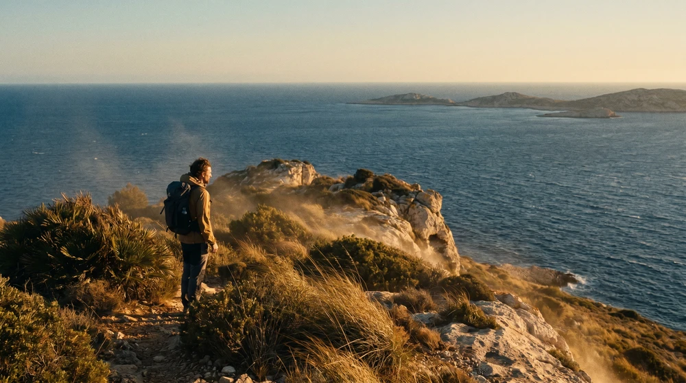
The Marfa Ridge loop delivers an unbroken panorama of the northern coastline, with Comino and Gozo dominating the horizon. Strong crosswinds frequently sweep across Aħrax Point, making lightweight windbreakers necessary even on clear, sunny days.
- Total distance: 8 km (loop)
- Difficulty: moderate
- Bus connections: routes 41, 42, or 222 to Mellieħa, followed by route 49 to Armier Bay
Għajn Tuffieħa to Ġnejna Bay Path
This path traces the eroded clay slopes separating two of Malta's most dramatic bays. Winter rains turn the red clay into a slick hazard, so use extreme caution near the unguarded cliff edges.
- Total distance: 3 km (one way)
- Difficulty: moderate to hard (steep, slippery inclines)
- Bus connections: routes 44 or 225 to Għajn Tuffieħa, return via route 101 from Ġnejna Bay
This stretch sits inside Il-Majjistral Nature and History Park, which is free to enter year-round. The park has no shade structures or shops inside its boundaries, so carry your own water before setting off. If you would rather swim than climb, the top sandy beaches on both islands include these same coves, with notes on access and shade.
Historic Trails and Cliffs in Central and Southern Malta
Victoria Lines (The Great Wall of Malta)
This 19th-century British fortification cuts straight across the island's natural fault line. The stone walls crumble in several sections, forcing you to navigate rugged, uneven valleys and thick Mediterranean scrub. The most striking stretch is the Bingemma Gap, where the wall bridges a deep green valley with caves carved into the rock face. Climbers head to these same inland faces and the island's sea cliffs, mapped in our guide to rock climbing in Malta.
- Total distance: 12 km (total length, easily segmented)
- Difficulty: moderate
- Walking time: roughly 3 to 4 hours for the full length
- Bus connections: route 44 to Mġarr provides excellent access to the scenic western segments
Dingli Cliffs and Fawwara Trail
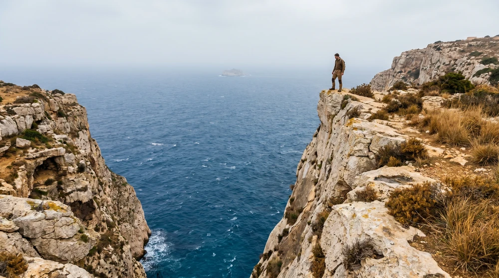
Standing at Malta's highest point, these plunging limestone walls offer an uninterrupted view of the Mediterranean and the uninhabited islet of Filfla. There are no guardrails here, so keep a safe distance from the fragile edges, especially when capturing photos.
- Total distance: 4 km (linear)
- Difficulty: easy
- Bus connections: route 201 efficiently links the cliffs directly with Mdina and the Blue Grotto
Best Hiking Trails in Gozo
Gozo is the quieter, greener of the two islands, with less development and more open countryside, which makes it the stronger choice for serious walkers. Getting there is simple once you sort out the crossing from the main island.
Ta' Ċenċ and Sanap Cliffs
Gozo's southern coastline feels remarkably isolated compared to the main island. The sheer vertical drops at Ta' Ċenċ provide excellent vantage points for spotting migratory seabirds riding the thermal currents. The viewpoint sits on privately owned land, but respectful access is permitted.
- Total distance: 4 km (return), extendable to 9 km along the full Xlendi cliff line
- Difficulty: easy to moderate
- Bus connections: route 305 from Victoria drops you directly in Sannat Square
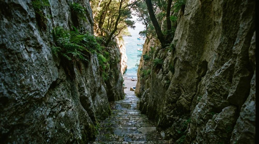
Wied il-Għasri to Xwejni Salt Pans
A narrow, winding gorge cuts deep into the limestone, creating a sheltered inlet that eventually meets the open sea. Stone steps carved directly into the rock lead down to a tiny, secluded pebble beach.
- Total distance: 3 km (return)
- Difficulty: easy
- Bus connections: route 309 to Żebbuġ, followed by a steady walk down the valley roads
Essential Logistics for Hiking in Malta
Navigating to Trailheads with Public Buses
Malta's bus network reaches almost every corner of the islands, but frequency drops significantly outside peak tourist centers. A single fare is €1.50 in winter and €2.00 in summer, while a 7-day Explore card costs €21 and a single-day pass runs €5, which quickly pays off if you tackle several linear hikes.
Always check the Tallinja app before starting a linear hike to confirm a return bus actually exists at your planned exit point. Missing the last afternoon bus from a remote area like Fawwara means a long, dark walk along unlit country roads. Timetables and ticket tiers shift outside summer, and moving around the islands by bus covers the full picture before you plan a linear route.
Terrain, Footwear, and Safety Warnings
Maltese trails consist primarily of jagged coralline limestone, which easily shreds standard athletic sneakers. Pack sturdy trail running shoes or light hiking boots with high-traction soles.
Bring a minimum of two liters of water per person, regardless of the season. Natural freshwater springs are virtually nonexistent on the trails, and the coastal humidity drastically accelerates dehydration.
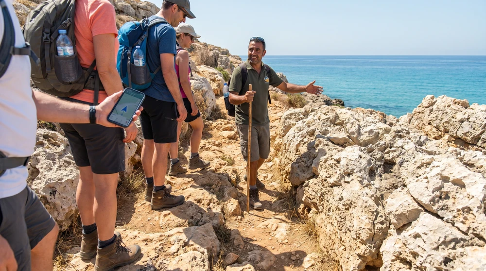
Most rural paths are unmarked, so an offline GPS map is non-negotiable to avoid wandering onto private farmland or unstable cliff edges. If solo navigation feels risky, you can book a guided coastal walk and let a local handle the route-finding.