Booking a standard cruise excursion to Mount Liamuiga often leaves travelers completely unprepared for the brutal, muddy inclines that actually await them. This is not a casual walk in the rainforest, but a demanding physical test that requires serious stamina, proper footwear, and plenty of water to conquer St. Kitts' highest peak.
- Summit elevation: 3,792 ft (1,156 m)
- Total duration: 4 to 5 hours round trip
- Distance: approximately 4.5 miles out and back
- Difficulty: strenuous, with steep bouldering and rope-assisted sections
- Trail condition: extremely muddy, exposed roots, slippery scrambles
- Water needed: 2-3 liters per person
- Best months: December to May (dry season)
- Starting point: Newton Ground trailhead, west coast of St. Kitts
- Guide: strongly recommended for safety and pacing on the final scramble
How Difficult is the Mount Liamuiga Hike?
If you would rather have a vetted operator handle transport, gear, and pacing, Book a guided Mount Liamuiga volcano hike from Basseterre. Adventure-grade activities like this are exactly the kind of trip where you want backup, so consider Travel insurance with hiking coverage before you fly.
Expect a Type 2 fun experience, exhausting in the moment but incredibly rewarding once you finish. The first half feels like a steep uphill hike, but the second half quickly turns into a near-vertical scramble. You navigate sections with a 30 to 70 percent grade, constantly pulling yourself up over giant boulders and thick, slippery tree roots. The actual vertical climb runs close to 2,350 ft (700 m) from the trailhead to the crater rim.
The descent is often harder than the climb. Your legs will be completely fatigued, and the slick mud, sometimes up to six inches deep, makes slipping a constant hazard. If you are not in decent athletic shape, this trail will break you within the first twenty minutes. Your muscles will likely ache for days afterward. Experienced hikers who regularly take on Colorado 14ers or Appalachian Trail sections still flag this climb as significantly harder than the cruise-excursion brochures suggest, so calibrate expectations even if you are in steady hiking shape.
Do You Really Need a Local Guide for Mount Liamuiga?
Orange paint marks, yellow ribbons, and a heavily trodden dirt path make the main route almost impossible to lose. If you rent a car and drive to the trailhead, tackling the mountain independently is entirely doable. You control your own pace, which is a massive advantage over large, rushed groups.
However, hiring an independent local guide adds undeniable value. Veterans of the trail know exactly where to place your feet on the sketchy final rock climb leading to the crater rim, and rope-assisted sections near the top are easier with someone who has done them dozens of times. They also share fascinating details about the medicinal plants lining the path and manage emergency situations if someone experiences extreme fatigue. Established operators include Greg's Safaris, O'Neil's Rainforest Tours, and Island Paradise Tours, whose senior guides like Doobie blend pacing with detailed botanical commentary on the way up.
Avoid the large cruise-line excursions if possible, especially the Royal Caribbean package, which carries a hard six-hour return window that includes two hours of driving. The schedule forces only 30-second water breaks and pushes inexperienced climbers to dangerous fatigue. Independent guided rates are private and change frequently, so confirm the current quote directly with the operator before you book.
The hike is not appropriate for young children. A reasonable lower bound is athletic, instruction-following kids aged eight or older; below that, the rope-assisted scrambles and slippery boulder fields create real injury risk on both the climb and the descent.
Getting to the Trailhead
The base of Mount Liamuiga sits on the northwest side of the island, far from the main tourist hubs. The official start is the Newton Ground trailhead, reached by a rough narrow road climbing south out of Newton Ground village. From Basseterre the drive takes roughly 40 minutes each way, and there is a parking lot with space for cars and minibuses just beyond the trailhead.
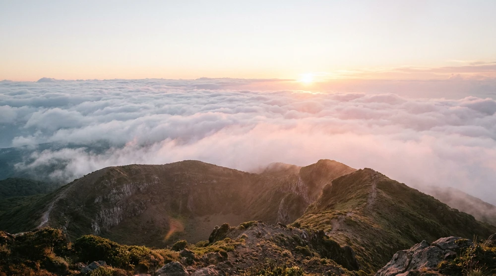
You will not find any taxis waiting around to take you back after your hike. If you are hiking independently, you must arrange a reliable round-trip transport service in advance or secure a rental car. Traffic around rush hour can easily delay your return trip, so factor this into your schedule if you have a strict cruise departure time to meet. Most guided groups leave Frigate Bay or Basseterre between 6 AM and 7 AM to reach the summit before afternoon clouds settle over the crater.
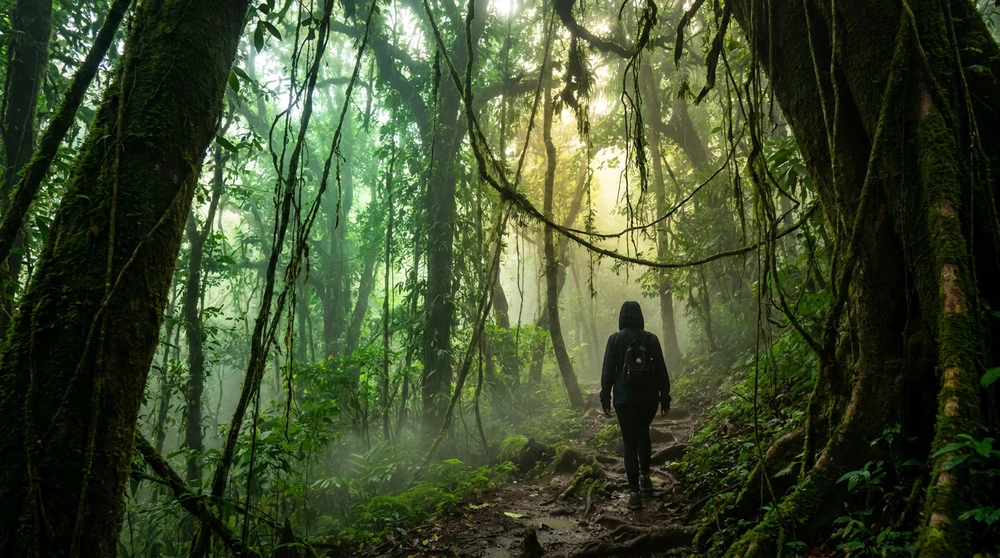
The Trail Experience: From Cloud Forest to the Crater Rim
The First Half: Humid Jungle and Vervet Monkeys
Right after you pass the quirky trailhead tree covered in abandoned, muddy shoes, the path plunges you straight into the dense cloud forest. The canopy provides roughly 95 percent shade, completely shielding you from the harsh Caribbean sun. The humidity at the lower elevations is intensely heavy, making you sweat out your water reserves almost immediately.
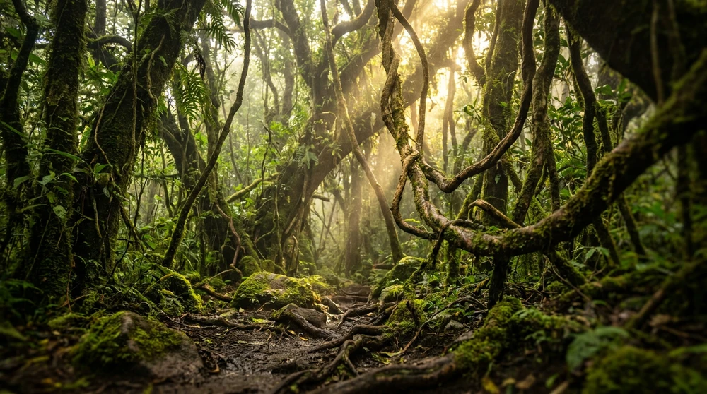
Keep your eyes on the high branches and the underbrush. You have a solid chance of spotting wild Vervet monkeys swinging through the trees, alongside local mongoose and anole lizards. Thankfully, the jungle here is surprisingly free of mosquitoes and biting bugs, with only the occasional spider web crossing the path.
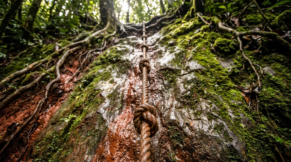
The Final Ascent: Bouldering and Slippery Roots
As you gain elevation, the temperature drops, offering a refreshing break from the lower jungle humidity. The trail layout completely changes here. The dirt path disappears, replaced by an obstacle course of damp soil, sharp rocks, and crisscrossing roots. Knotted ropes appear in two or three of the steepest sections, and you will need both hands free for the final push.
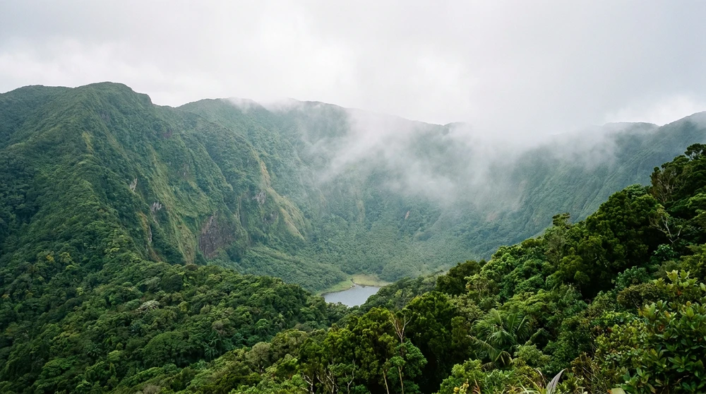
Space at the top is extremely tight. A small rocky platform holds about five to seven adults safely. Dense vegetation frames the deep crater lake, offering a narrow, rugged view rather than a wide-open panorama. A short permanent ladder climbs a large boulder formation on the rim and opens up the best vantage point for photos, so swing right when you reach the saddle. On a clear day you can spot Antigua on the eastern horizon beyond the Caribbean Sea, and after a rainy week temporary waterfalls slip down the inner crater walls. You will see sketchy ropes leading down into the crater itself, but venturing into the crater is highly dangerous and not recommended without a specialist guide.
Essential Packing List: Leave Your Running Shoes at Home
Standard running shoes will get completely destroyed on this mountain. Ankle-supportive hiking boots with deep tread are non-negotiable for gripping the wet roots and surviving the muddy descent. Wear long pants to protect your legs from inevitable scrapes and mud splatters when you slip.
Water is your biggest priority. Bring at least 3 liters of water per person if you sweat heavily, and a strict 2-liter minimum for everyone else, since there are absolutely no shops or fresh water sources anywhere near the trail. Pack high-energy snacks like jerky or protein bars. Trekking poles are incredibly useful for maintaining balance on the way down, though you will need to stash them away during the hands-on rock scrambling sections near the summit.
Best Time of Year to Climb
Plan your hike during the dry season, roughly December through May. Trails are firmer, crater visibility improves dramatically, and the chance of being caught in a sudden downpour drops significantly. Hurricane season runs June through November, with peak storm risk in August and September, and hurricane-season hiking can be genuinely dangerous on the upper boulder sections when rain saturates the soil. If you must hike outside the dry window, watch the forecast closely and turn back if heavy rain rolls in while you are on the steep middle stretch.