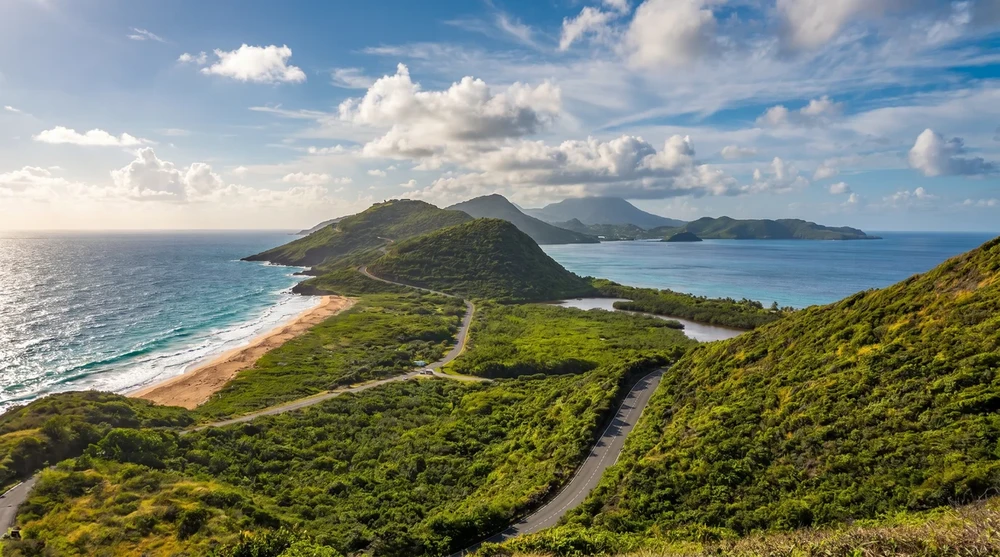
The reefs around St. Kitts and Nevis are not the postcard Caribbean barrier system. Instead you get volcanic boulder fields, two reachable wrecks, and a protected marine park on the west coast that rewards strong swimmers. Most visitors plan one shore swim and one boat trip and leave with the same short list of memories: a tugboat covered in soft coral, a turtle grazing in seagrass, and eagle rays slipping past a wall.
- Best shore-snorkel spot: Whitehouse Bay sunken tugboat (the MV River Taw), south-east peninsula
- Best boat-snorkel area: Sandy Point National Marine Park, west coast of St. Kitts
- Water temperature: 26 to 29 C (79 to 84 F) year-round, coolest in February
- Average visibility: 15 to 25 metres in the dry season, hazier on the Caribbean side in late summer storms
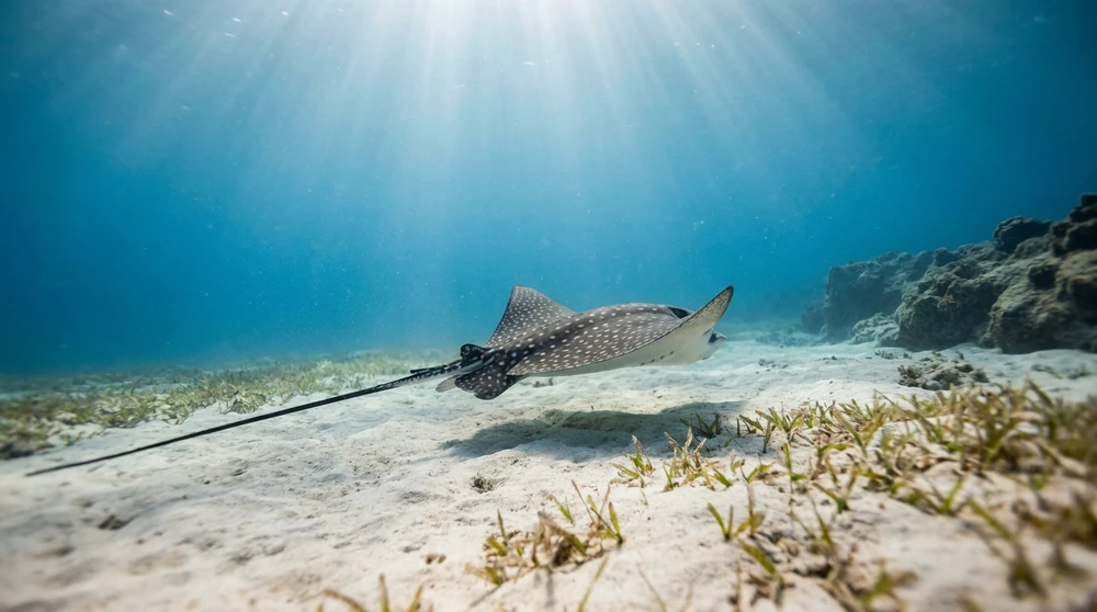
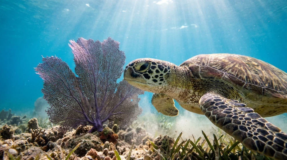
- Top species expected: green and hawksbill sea turtles, eagle rays, parrotfish, southern stingrays, octopus
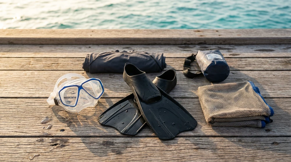
- Gear rental: available at Whitehouse Bay, Reggae Beach Bar, and Pinney's Beach (mask/fin/snorkel sets)
Marine Life and Volcanic Reef Conditions
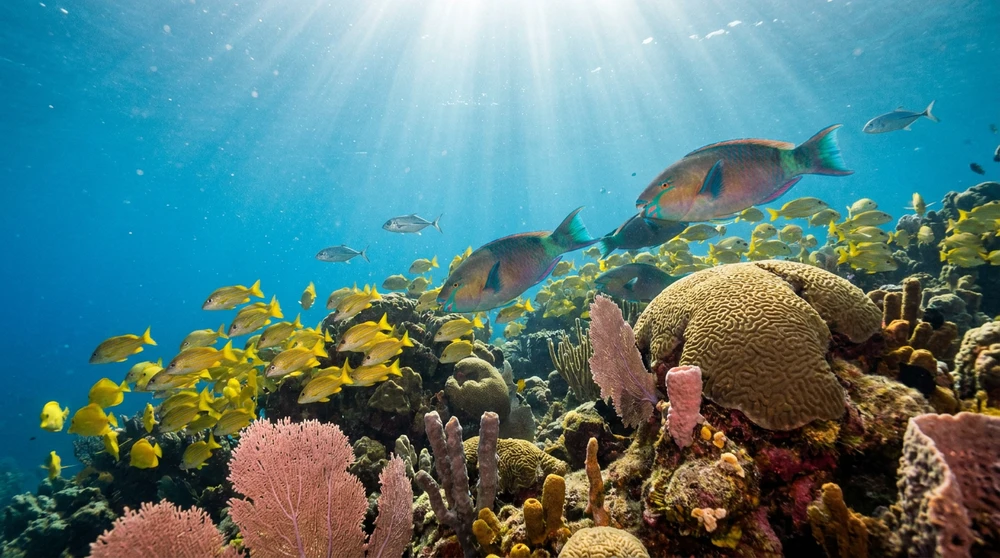
The underwater terrain reflects the islands' volcanic origin. Rather than a wide barrier reef, you swim over basalt boulders, submerged ledges, and steep drop-offs draped in sea fans, brain corals, and tube sponges. These structures shelter spiny lobsters, juvenile reef fish, and small moray eels in the cracks.
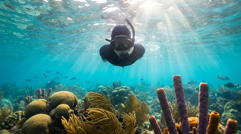
The signature sightings are the big ones. Green and hawksbill sea turtles graze on seagrass beds in shallow bays year-round and nest on local beaches between July and February. Spotted eagle rays patrol deeper edges and ride the current along walls. Schools of blue tangs, yellowtail snappers, and bar jacks move through the shallows, and at dusk you can find common octopus tucked into rocky holes around Whitehouse Bay.
Sea conditions are calmest along the Caribbean (west) coast. The Atlantic side gets swell year-round and is rarely worth a shore attempt without local advice.
Best Shore Snorkeling Spots in St. Kitts
Booked snorkel tours and gear packages are the easiest way to combine shore and boat sites, but most of these spots are also free to reach on your own with water shoes and a rental mask. Half-day catamaran trips cover the boat-only sites further south.
Whitehouse Bay and the MV River Taw
Whitehouse Bay sits on the south-east peninsula, a 20-minute drive from Basseterre on the road to Reggae Beach. The shoreline is rocky volcanic rubble rather than sand, so water shoes are essential. From the small parking area near Salt Plage Restaurant, walk south along the shore until you spot the outline of a dark wreck breaking the surface about 30 metres off the rocks. This is the MV River Taw, a 144-foot island cargo ship that began sinking in 1981 and broke into two sections during Hurricane Hugo in 1989.
The wreck rests in roughly 4 to 7 metres of water. The hull is encrusted with soft coral, fire coral, and sponges, and the broken sections create swim-throughs that attract schooling sergeant majors, damselfish, and the occasional barracuda. Visibility is usually 15 to 20 metres on a calm day. The bay is shielded from the prevailing wind, so even when the rest of the island gets choppy you can normally swim here.
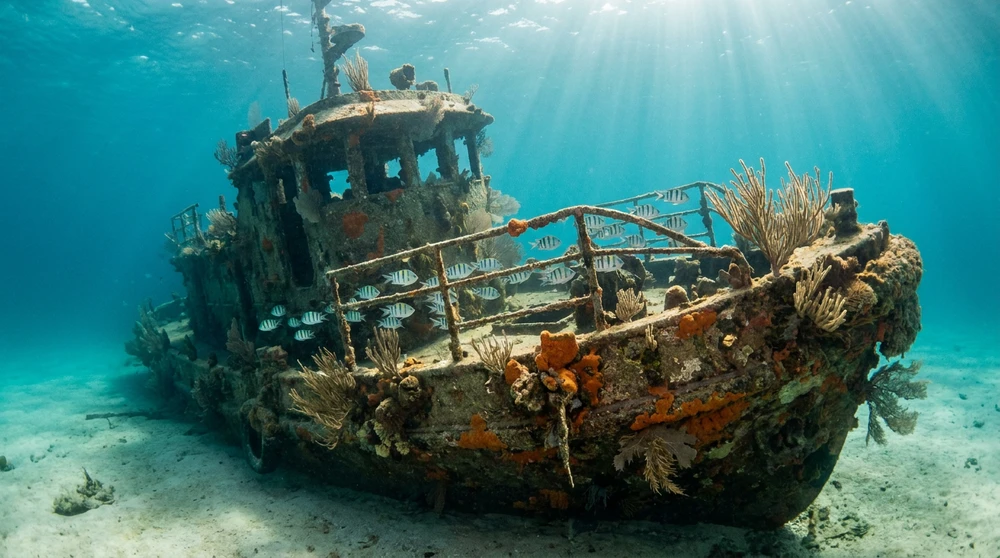
A second, older wreck (an 18th-century British troop ship) lies further out toward the centre of the bay, but most snorkelers stay with the tugboat.
Reggae Beach Bar Boulder Line
The southern end of South Friar's Bay, behind Reggae Beach Bar (also called Carambola Beach Club at some properties), offers an immediate sand entry. Swim south parallel to the rocky shelf that runs along the peninsula and the bottom drops gradually to about 6 metres. Hawksbill turtles feed along this ledge in the mornings, and the deeper crevices hold spiny lobsters and the occasional spotted moray. The bar makes a good base for a half-day stop and rents masks and fins for around US$10 to US$15.
Cockleshell Bay and Sand Bank Bay
The two long sand beaches at the foot of the peninsula are better for swimming than snorkeling, but the rocky points at each end produce decent fish life. Cockleshell sits on the Caribbean side, so the water stays calmer and warmer than the Atlantic-facing resorts up at Frigate Bay. The shoreline lives up to its name with conch shells washed up along the sand and embedded in the shallows, and curious snorkelers regularly find them on short swims toward the eastern headland. Watch for fishing skiffs and small tour boats near the central pier, since they come in fast and the captains do not always slow down. A mangrove lagoon behind the beach can leave a strong organic smell on still days but does not affect the swim line.
Cockleshell is also the launch point for short boat hops to Nevis, which puts you straight onto the Pinney's Beach turtle grounds without a full-day charter. Spice Mill and a row of independent beach huts handle food and drink between sessions, and the smaller huts often rent two chairs with an umbrella for around US$8 instead of the US$10 the bigger venues charge.
Shore-Snorkel Spot Comparison (St. Kitts)
| Location | Entry | Highlight | Difficulty |
|---|---|---|---|
| Whitehouse Bay (MV River Taw) | Rocky, water shoes required | Shipwreck and soft coral | Easy to moderate |
| Reggae Beach (Friar's Bay south) | Sand, walk south to rocks | Turtle ledge, lobsters | Easy |
| Cockleshell Bay points | Sand, swim to headlands | Schooling fish, calm water | Easy |
| Sand Bank Bay rocks | Sand, north or south point | Bar jacks, sea whips | Moderate (current) |
Best Boat-Only Sites: Sandy Point Marine Park and Nag's Head
For the strongest fish density and the chance at eagle rays, you need a boat. Two areas dominate the local tour itineraries.
Sandy Point National Marine Park runs along the west coast of St. Kitts between Sandy Point Town and the Brimstone Hill fortress. The protected reef sits in 3 to 10 metres for snorkel-friendly sections (it drops to 30 metres for divers) and shelters green and hawksbill turtles, creole wrasse, barracuda, moray eels, and the occasional seahorse on the deeper edges.
Recent mooring buoys have reduced anchor damage to the corals, and conservation surveys report improving reef health. Snorkel routes typically cover 200 to 500 metres depending on tide and current.
Nag's Head marks the southern tip of St. Kitts, where the Caribbean meets the Atlantic. Volcanic boulders covered in fire coral and sponge form a mini-wall down to about 25 metres. Eagle rays feeding on nearby grass beds glide along this wall, and parrotfish and feather stars work the boulder tops. Currents can be strong, so the site is best reached as part of a guided snorkel charter rather than a DIY swim.
Shitten Bay, tucked behind cliffs on the south coast, is boat-only and tends to deliver high visibility and intact coral. Most operators package these three sites into a single half-day or full-day catamaran trip with lunch.
Snorkeling in Nevis: Pinney's Beach and the Four Seasons Breakers
The west coast of Nevis is the calmer of the two islands and gets most of the day-tripping snorkelers off the Sea Bridge ferry.
Pinney's Beach stretches roughly 5 kilometres north from Charlestown along the Caribbean coast. The shore is soft sand, the water rarely rises above waist height for the first 30 metres, and green and hawksbill turtles graze on the seagrass beds close to shore from dawn through mid-morning. Stingrays drift along the bottom, and schools of small reef fish work the shallows.
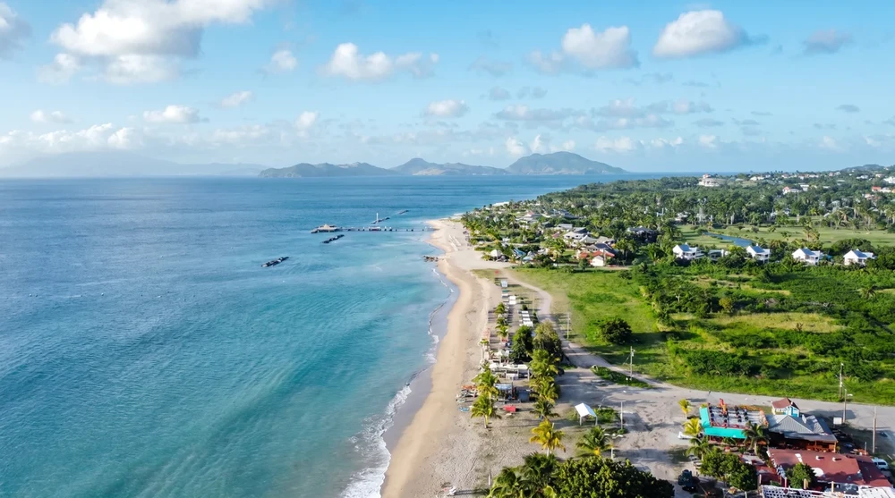
The signature spot here is the Four Seasons Breaker rock piles. Four man-made breakwaters in front of the Four Seasons Resort create the most reliable shore snorkel on Nevis. The structures shelter parrotfish, sergeant majors, occasional nurse sharks, and small reef sharks closer to the deeper channel. All Nevis beaches are public to the high-water mark, so you can park at the public Pinney's lots, walk north, and enter the water without paying any resort fee.
Nevis Snorkel Sites at a Glance
| Location | Entry | Highlight | Difficulty |
|---|---|---|---|
| Pinney's Beach (north end) | Soft sand | Turtles in seagrass, rays | Easy |
| Four Seasons Breaker | Sand walk-in | Reef fish, occasional nurse shark | Easy |
| Oualie Beach reef | Sand | Patch reef, small fish | Easy |
| Newcastle Bay | Sand and rock | Eagle rays (boat preferred) | Moderate |
Visibility, Weather, and the Best Months to Plan Around
Both islands sit in the leeward Caribbean, which means the west-facing shores are normally calm and the east-facing Atlantic side is rough. Plan all shore snorkel days on the Caribbean coast.
Dry season (December to April) delivers the clearest water. Expect visibility of 20 to 25 metres on calm days, water temperature near 26 to 27 C, and almost no rain. This is the standard cruise-ship window, so popular sites like Whitehouse Bay get crowded between 10:00 and 14:00.
Shoulder months (May, June, November) are the sweet spot. Seas stay calm, water rises to 28 C, crowds thin out, and most operators are still running daily trips. Visibility remains strong if no tropical storms are spinning.
Late summer (August to October) is the trade-off period. Water is warmest at 29 C, but Caribbean-side visibility can drop to 10 to 15 metres when storm swell stirs up sediment, and there is a real hurricane risk between mid-August and late October. Plenty of trips still run, just check the forecast 48 hours out.
Turtle viewing window: Hawksbill and green sea turtles nest on local beaches from July through February, with the highest in-water sightings between June and October when juveniles feed in the shallow seagrass beds.
Safety: What Actually Matters Underwater
The bigger danger in St. Kitts and Nevis is not the marine life. It is the combination of post-flight fatigue, sun exposure, and badly fitted gear. Three rules cover almost every preventable accident:
Wait 24 to 48 hours after a long-haul flight before strenuous swimming. Pressurised cabin air leaves the lungs with reduced compliance for a day or two. Pulmonary edema among snorkelers is rare but documented, and it correlates with hard exertion in the first 48 hours of a trip.
Use an open-bore snorkel, not a sealed dry-top model. Dry valves add inhalation resistance that increases negative pressure in the chest when you swim hard or dive down. A simple J-tube with a splash guard is safer for most people.
Wear water shoes and a rash vest. The volcanic shore at Whitehouse Bay and Reggae Beach is brutal on bare feet. Spiny sea urchins and fire coral are common around the boulder lines, and the equatorial sun burns shoulders in under 30 minutes.
If you feel unexpected shortness of breath, dizziness, or sudden chest tightness, signal for help, get out of the water, and rest. Do not push through it. Two dive shops on the south-east peninsula (in Frigate Bay and Basseterre) can advise on or transport to medical help if needed.
Getting Between the Islands With Gear
The Sea Bridge ferry carries cars and passengers between Major's Bay (St. Kitts) and Cades Bay (Nevis) on a roughly hourly schedule. Foot passenger ferries also run between Basseterre and Charlestown several times a day. Either crossing takes about 30 to 45 minutes and a one-way ticket is around US$10.
For independent travel on St. Kitts, a 150cc scooter is the most efficient way to reach the southern peninsula bays. Local rules let you operate a 150cc on a standard car licence, so you can carry a mask and fins to remote pull-offs that taxis bypass. Daily scooter rental runs roughly US$35 to US$50 from Basseterre operators.
Gear and Transport at a Glance
| Item | Estimated Daily Cost (US$) | Where to Find It |
|---|---|---|
| Mask, fin, snorkel set | US$10-15 | Whitehouse Bay, Reggae Beach Bar, Pinney's Beach kiosks |
| 150cc scooter | US$35-50 | Basseterre rental hubs |
| Cross-island passenger ferry | US$10 one way | Basseterre - Charlestown piers |
| Half-day snorkel charter | US$70-95 | South-east peninsula operators |
A short shore swim at the MV River Taw in the morning, a turtle pass off Pinney's Beach in the afternoon, and a single half-day charter to Sandy Point or Nag's Head cover the best of what these islands offer below the surface.