When planning a cross-country adventure, understanding the sheer scale of the United States is crucial. A road trip across Rhode Island might take you 45 minutes, but driving across Texas can easily take over 12 hours. The United States is a massive patchwork of 50 states, each varying wildly in geography and size.
While most people know Alaska is the giant of the north, the ranking of the other 49 states often surprises travelers. Are you curious about how much land area California actually covers compared to Montana? Or perhaps you are wondering which states are the tiniest?
Here is the definitive guide to US states by size, ranked by total area and land area, to help you visualize the map better for your next journey.
Before learning the full list, here are the record-holders that define the American landscape:
Largest State: Alaska (Huge enough to fit Texas inside it twice!)
Smallest State: Rhode Island
Largest State in the Lower 48: Texas
AdvertisementTotal US Area: Approximately 3.8 million square miles
The Titans: Top 5 Largest States in the US
These five states account for a massive portion of the country's total landmass. If you are planning a USA road trip, be prepared for long stretches of driving when visiting these giants.

1. Alaska
Total Area: 665,384 sq mi
Alaska is in a league of its own. It is not just the largest state; it is colossally bigger than anything else. To put it in perspective, Alaska is larger than Texas, California, and Montana combined. However, much of this vast wilderness is inaccessible by road, making it a unique challenge for travelers.
2. Texas
Total Area: 268,596 sq mi
Everything is bigger in Texas, or so the saying goes. As the largest state in the contiguous US (the Lower 48), Texas dominates the map. Its sheer size means it spans multiple climate zones, from the humid bayous of the east to the arid deserts of the west.
3. California
Total Area: 163,695 sq mi
California is the third-largest state and offers arguably the most diverse landscape per square mile. You can go from the snowy peaks of the Sierra Nevada to the scorching heat of Death Valley in a single day.
4. Montana
Total Area: 147,040 sq mi
Known as Big Sky Country, Montana’s wide-open spaces make it feel even larger than it is. It is a paradise for outdoor lovers, hosting a significant part of Yellowstone and all of Glacier National Park.
5. New Mexico
Total Area: 121,590 sq mi
Rounding out the top five is the Land of Enchantment. New Mexico’s vast high deserts and mountain ranges offer a distinct driving experience that feels ancient and expansive.
Land Area vs. Total Area: Why It Matters
When looking at state sizes, there is a technical detail that changes the ranking: water. Some states, like Michigan and Florida, have massive amounts of territory covered by lakes and coastal waters.
For example, if you rank by Total Area, Michigan is the 11th largest state because of the Great Lakes. However, if you look strictly at Land Area (solid ground you can stand on), Michigan drops significantly in the rankings. For travelers renting a car in the USA, land area is often the more practical metric to consider for driving distances.
Complete List of US States by Size (Ranked)
Here is the full breakdown of all 50 states plus the District of Columbia, ranked by their total area.
| Rank | State | Total Area (sq mi) | Land Area (sq mi) |
|---|---|---|---|
| 1 | Alaska | 665,384 | 570,641 |
| 2 | Texas | 268,596 | 261,232 |
| 3 | California | 163,695 | 155,779 |
| 4 | Montana | 147,040 | 145,546 |
| 5 | New Mexico | 121,590 | 121,298 |
| 6 | Arizona | 113,990 | 113,594 |
| 7 | Nevada | 110,572 | 109,781 |
| 8 | Colorado | 104,094 | 103,642 |
| 9 | Oregon | 98,379 | 95,988 |
| 10 | Wyoming | 97,813 | 97,093 |
| 11 | Michigan | 96,714 | 56,539 |
| 12 | Minnesota | 86,936 | 79,627 |
| 13 | Utah | 84,897 | 82,170 |
| 14 | Idaho | 83,569 | 82,643 |
| 15 | Kansas | 82,278 | 81,759 |
| 16 | Nebraska | 77,348 | 76,824 |
| 17 | South Dakota | 77,116 | 75,811 |
| 18 | Washington | 71,298 | 66,456 |
| 19 | North Dakota | 70,698 | 69,001 |
| 20 | Oklahoma | 69,899 | 68,595 |
| 21 | Missouri | 69,707 | 68,742 |
| 22 | Florida | 65,758 | 53,625 |
| 23 | Wisconsin | 65,496 | 54,158 |
| 24 | Georgia | 59,425 | 57,513 |
| 25 | Illinois | 57,914 | 55,519 |
| 26 | Iowa | 56,273 | 55,857 |
| 27 | New York | 54,555 | 47,126 |
| 28 | North Carolina | 53,819 | 48,618 |
| 29 | Arkansas | 53,179 | 52,035 |
| 30 | Alabama | 52,420 | 50,645 |
| 31 | Louisiana | 52,378 | 43,204 |
| 32 | Mississippi | 48,432 | 46,923 |
| 33 | Pennsylvania | 46,054 | 44,743 |
| 34 | Ohio | 44,826 | 40,861 |
| 35 | Virginia | 42,775 | 39,490 |
| 36 | Tennessee | 42,144 | 41,235 |
| 37 | Kentucky | 40,408 | 39,486 |
| 38 | Indiana | 36,420 | 35,826 |
| 39 | Maine | 35,380 | 30,843 |
| 40 | South Carolina | 32,020 | 30,061 |
| 41 | West Virginia | 24,230 | 24,038 |
| 42 | Maryland | 12,406 | 9,707 |
| 43 | Hawaii | 10,932 | 6,423 |
| 44 | Massachusetts | 10,554 | 7,800 |
| 45 | Vermont | 9,616 | 9,217 |
| 46 | New Hampshire | 9,349 | 8,953 |
| 47 | New Jersey | 8,723 | 7,354 |
| 48 | Connecticut | 5,543 | 4,842 |
| 49 | Delaware | 2,489 | 1,949 |
| 50 | Rhode Island | 1,545 | 1,034 |
| - | Washington D.C. | 68 | 61 |
The Smallest States: Tiny but Mighty
On the other end of the spectrum, the northeastern United States is home to the smallest states. While they lack in square mileage, they make up for it with high population density and rich history.
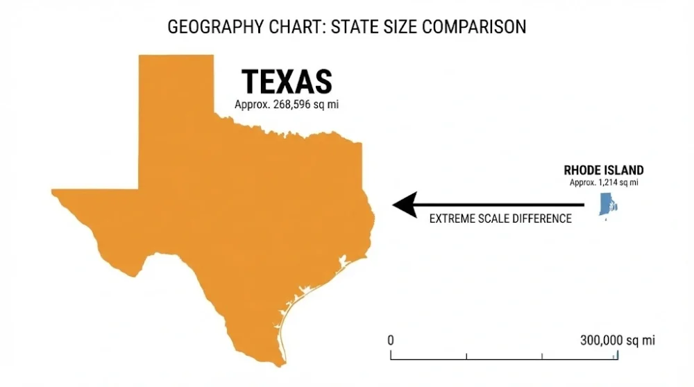
Rhode Island, the smallest state, is often a point of confusion. Despite its name, it is not an island but a coastal state. Its total area is just 1,545 square miles. To visualize this, you could fit 430 Rhode Islands inside Texas!

Delaware and Connecticut follow closely. For road trippers, these states are a breeze to navigate. You can drive across the entire state of Delaware in under two hours, making it easy to visit multiple states in a single day in this region.
Fun Comparisons: Putting Size into Perspective
Numbers can be dry, so let's look at some fun comparisons to help you understand the scale:
Alaska vs. The World: If Alaska were an independent country, it would be the 17th largest country in the world, ranking just below Libya and above Iran.
California's Reach: California is roughly the same size as Sweden or Iraq.
AdvertisementThe Texas Drive: Driving from Beaumont (East Texas) to El Paso (West Texas) is roughly 857 miles. That is farther than the distance between New York City and Jacksonville, Florida!
Rhode Island: It is so small that some larger ranches in Texas are actually bigger than the entire state of Rhode Island.
Understanding these sizes helps you plan better itineraries. When you see a route on a map in the West, do not underestimate the scale. Those "short" distances between towns in Montana or Nevada might actually take hours to drive. Always check your fuel levels and carry supplies when traversing the top-ranking states on this list.