Everyone assumes the Grand Canyon holds the depth record. That assumption is factually wrong. The United States harbors massive geological fractures that plunge far deeper than Arizona's famous landmark.
Finding the actual deepest gorge requires looking past the fame and focusing strictly on the numbers. Here is the true ranking of the deepest canyons across the country.
| Rank | Canyon Name | State(s) | Maximum Depth | River Source |
|---|---|---|---|---|
| 1 | Hells Canyon | Idaho, Oregon, Washington | 7,993 Feet | Snake River |
| 2 | Kings Canyon | California | 7,700 Feet | Kings River |
| 3 | Grand Canyon | Arizona | 6,093 Feet | Colorado River |
| 4 | Desolation Canyon | Utah | 5,000 Feet | Green River |
| 5 | Columbia River Gorge | Oregon, Washington | 4,000 Feet | Columbia River |
How Is Canyon Depth Actually Measured?
People often confuse canyon depth with elevation range. Elevation range measures the highest mountain peak in a region against the lowest valley floor, even if they are miles apart. That metric does not give you the true feel of looking down a sheer cliff.
True canyon depth requires a vertical drop measurement. You calculate the distance from the riverbed to the immediate river surface, then measure straight up to the nearest adjacent rock wall or rim. This strict vertical measurement is exactly how Hells Canyon beats the competition by thousands of feet. Keep this technical difference in mind when you evaluate extreme landscapes.
1. Hells Canyon - 7,993 Feet
The landscape is wild, the isolation absolute. Hells Canyon is the undisputed king of depth in North America. The Snake River spent millions of years carving this massive trench through layers of volcanic basalt and sedimentary rock.
Best Viewpoints and Access
Drive the Hells Canyon Scenic Byway for the easiest panoramic access. The roads are winding and steep, so take your time on the curves. For a view straight down into the abyss, hike up to Hat Point.
Practical Information
- Location: Straddles the borders of Idaho, Oregon, and Washington.
- Activities: Epic whitewater rafting and remote backpacking.
- Vibe: Extremely remote with zero cell service.
2. Kings Canyon - 7,700 Feet
Granite walls tower overhead, while lush green meadows blanket the valley floor. Kings Canyon sits deep within the Sierra Nevada mountains. Unlike river-carved slots, this massive trench features classic U-shaped valleys formed by ancient glacial movements.
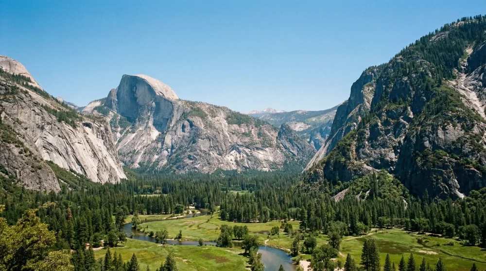
Best Viewpoints and Access
Stop at Canyon View Overlook. The viewpoint offers a clear, unobstructed line of sight directly to Buck Peak and Mount Clarence King. Bring a wide-angle lens to capture the sheer scale of the granite faces.
Practical Information
- Location: California.
- Terrain: Steep, glaciated craggy terrain.
- Highlights: Proximity to Grant Grove, home to some of the tallest sequoia trees on the planet.
3. Grand Canyon - 6,093 Feet
Red rock layers stretch endlessly, the horizon completely fractured. The Grand Canyon is undoubtedly the most famous natural wonder in the country. The Colorado River exposed billions of years of geological history as it sliced through the desert crust.
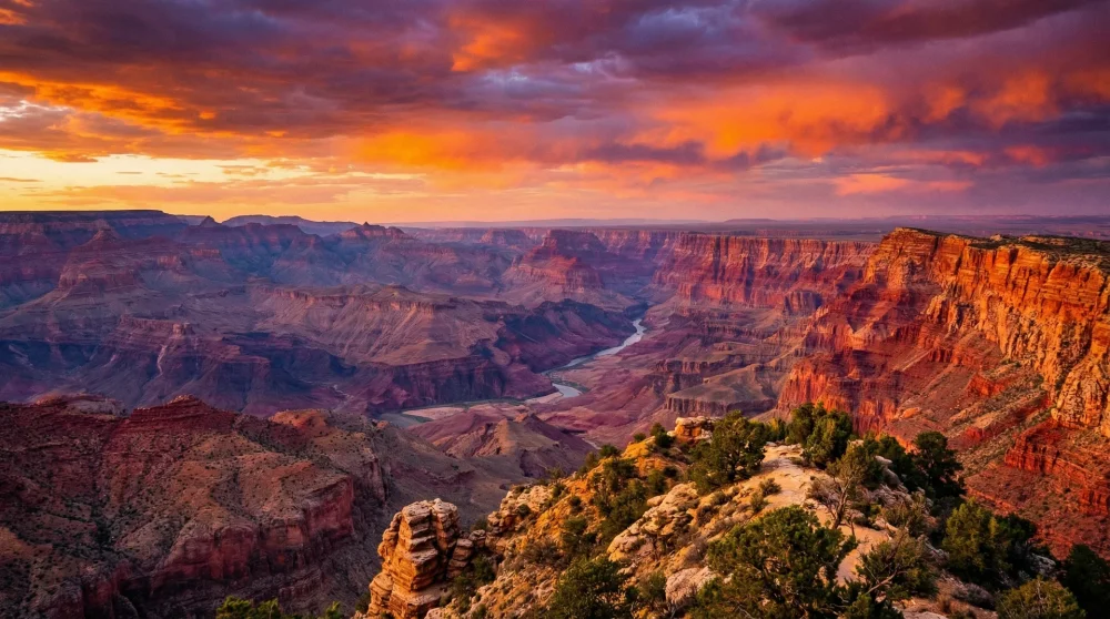
Best Viewpoints and Access
Use the Desert View Road for sweeping, expansive panoramas. Walk the Canyon Rim Trail if you want a closer look at the sheer drop without committing to a strenuous hike. Start your day early to secure a good parking spot.
Practical Information
- Location: Arizona.
- Scale: An incredible 277 miles long and up to 18 miles wide.
- Crowds: Extremely high traffic at the main rims.
4. Desolation Canyon - 5,000 Feet
The terrain is harsh, the silence deafening. Desolation Canyon hides in a highly remote region of eastern Utah. Geologist John Wesley Powell named it perfectly after experiencing its inhospitable, rugged nature during an early expedition.
Best Viewpoints and Access
Access is incredibly difficult by car. Book a multi-day rafting trip on the Green River to truly see the interior walls. Pack thoroughly, because you are entirely on your own once you enter the waterway.
Practical Information
- Location: Utah.
- Landscape: Arches, pinnacles, and dense pinyon-juniper woodlands.
- Ideal for: Experienced river rafters and backcountry explorers.
5. Columbia River Gorge - 4,000 Feet
Misty air, towering basalt cliffs, and roaring waterfalls. The Columbia River Gorge forms a massive natural border between two states. Cataclysmic ancient floods ripped through this area, massively eroding the landscape into the deep gorge you see today.
Best Viewpoints and Access
Drive the Historic Columbia River Highway for a highly scenic route. Stop frequently to admire the sheer drops at Multnomah Falls and Latourell Falls. Keep rain gear handy, as the weather shifts rapidly.
Practical Information
- Location: Oregon and Washington.
- Climate: Wet and deeply forested on the west end, dry and arid on the east.
- Activities: World-class windsurfing at Hood River.
6. McKittrick Canyon - 3,200 Feet
Bright autumn foliage pops violently against stark white limestone walls. Located in Guadalupe Mountains National Park, McKittrick Canyon exposes an ancient marine reef. You can actually see fossils of sponges and algae embedded right in the canyon walls.
Best Viewpoints and Access
Take the relatively flat hike to Pratt Cabin. The trail is highly scenic and puts you right in the heart of the gorge. Wear sturdy hiking boots to handle the rocky stretches.
Practical Information
- Location: Texas.
- Geology: Rich in Permian period marine fossils.
- Seasons: Famous for spectacular, unexpected fall colors in a desert environment.
7. Waimea Canyon - 3,000 Feet
Deep red dirt, vibrant green vegetation, and low-hanging clouds. Known as the Grand Canyon of the Pacific, Waimea Canyon sits on the Hawaiian island of Kauai. Extreme rainfall and a massive volcanic collapse created this tropical chasm.
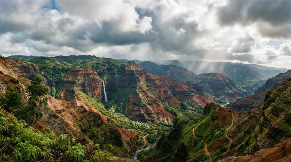
Best Viewpoints and Access
Follow Waimea Canyon Drive all the way up. Stop at the main Waimea Canyon Lookout and Puu Hinahina Lookout for the absolute best angles. Arrive early in the morning before the afternoon clouds roll in and obscure the view.
Practical Information
- Location: Hawaii.
- Origin: Carved by the Waimea River and heavy tropical rains.
- Tip: The red clay stains clothing easily, so dress accordingly.
8. Linville Gorge - 2,800 Feet
Dense virgin forests, jagged rock spires, and steep vertical drops. Linville Gorge is one of the most rugged wilderness areas in the eastern states. Because the terrain was too extreme for logging, the old-growth forests here remain completely untouched.
Best Viewpoints and Access
Hike up to Table Rock or Hawksbill Mountain. The trails are steep and physically demanding, but they reward you with unobstructed views over the entire gorge. Pack a reliable map, as the wilderness trails are rough.
Practical Information
- Location: North Carolina.
- Nature: Framed by Jonas Ridge and Linville Mountain.
- Must-see: Linville Falls marks the dramatic beginning of the canyon.
9. Zion Canyon - 2,640 Feet
Massive sandstone walls, vibrant hanging gardens, and a narrow riverbed. Zion Canyon is the undisputed centerpiece of Utahs first national park. The Virgin River carved this deep slot, leaving behind striking red and white Navajo sandstone cliffs.
Best Viewpoints and Access
Ride the mandatory park shuttle to the Temple of Sinawava. Walk the paved Riverside Walk to see exactly where the canyon walls narrow into the famous Narrows section. Bring water shoes if you plan to wade upstream.
Practical Information
- Location: Utah.
- Colors: Deep rust reds blending into creamy whites.
- Wildlife: Look up to spot the highly endangered California condor gliding on thermals.
10. Bighorn Canyon - 2,500 Feet
Soaring vertical cliffs meeting deep blue waters. Bighorn Canyon straddles two northern states with immense geological drama. The river sliced directly through the uplifted crust of the local mountain range, exposing millions of years of rock layers.
Best Viewpoints and Access
Head to the rim of Bull Elk Ridge for a dizzying downward perspective. Alternatively, rent a boat on Bighorn Lake to view the towering walls from the absolute bottom. Keep a safe distance from the edges, as the rock can be unstable.
Practical Information
- Location: Montana and Wyoming.
- History: Holds thousands of years of human history, including ancient petroglyphs.
- Sights: Keep an eye out for wild horses roaming the surrounding harsh landscape.
Why the Grand Canyon Is Not the Deepest
Fame does not equal depth. The Grand Canyon dominates pop culture because of its immense width, vibrant colors, and easy accessibility. When you stand on the rim, the opposite side is so far away that it looks like an ocean of rock. That massive scale creates a powerful visual illusion.
However, when you measure purely by vertical drop, the math tells a different story. Hells Canyon and Kings Canyon both plunge significantly deeper into the earth. They lack the extreme width of the Grand Canyon, which actually makes their walls feel steeper and more imposing. Trust the actual topographical numbers over the popular reputation.